Idea / 001 / Endurance
THE HIGH-FLYER CLUB
A string of Brazen’s toughest half marathons, ridgelines, redwoods, and one very long way up.
Keep reaching for the clouds.
One of the things I loved about the Dipsea was the company. On the climbs, then again on the descents, I kept finding myself beside the same people. We didn’t need to say much. We were all working our way over the same hill, with a little more trail still ahead.
These races feel like an outstanding reason to keep that going. A new ridgeline to reach, a stretch of redwoods to disappear into, another morning spent outside with people who understand why you would sign up for all that climbing. There will be hills worth walking and descents that ask plenty of your legs. There will also be those moments when the trees open up and you remember what brought you out here.
That’s the appeal of the High-Flyer Club: keep reaching for the clouds, and join a fantastic group of billy goats along the way. Pick a trail, bring a friend, and see how much ground you can cover together. This is a list worth keeping close.
High Flyer status means accumulating at least four miles of climbing—21,120 feet—and completing the series: five eligible races plus the Rocky Ridge finale. The courses below include the two alternate Diablo distances.
The courses / January–December
15 / Options*Typical months are a planning guide based on Brazen’s published series schedule. Months and dates are subject to change; confirm the edition you plan to run with Brazen. Cards follow calendar-year order; the series itself spans two calendar years.
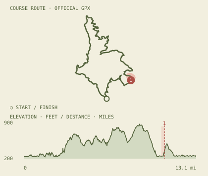
Brazen New Year’s Day Half
A mostly-dirt loop around Lake Chabot, run in reverse from the New Year’s Eve course.
Typically heldJanuary*
Cutoff checkpoints
- Aid station · 10.7 mi
Profile drawn from the organizer’s published route. Elevations and route versions may vary.
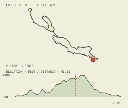
Diablo Trails Challenge
Dirt trails climb from Castle Rock toward Curry Point, then loop back through Mount Diablo State Park.
Typically heldApril*
Cutoff checkpoints
- Curry Point · 7.9 mi
Profile drawn from the organizer’s published route. Elevations and route versions may vary.
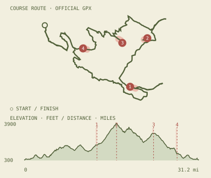
Diablo Trails Challenge
Castle Rock, Rock City, Curry Point, the summit, Juniper, and Burma mark the long mountain loop.
Typically heldApril*
Cutoff checkpoints
- Curry Point · 13 mi
- Summit · 16.5 mi
- Juniper · 23.1 mi
- Burma · 27.3 mi
Profile drawn from the organizer’s published route. Elevations and route versions may vary.
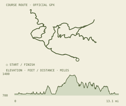
Badger Cove Half Marathon
A hilly loop through the emerald trails and rolling ridges around Lake Del Valle.
Typically heldApril*
Profile drawn from the organizer’s published route. Elevations and route versions may vary.
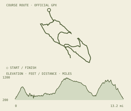
Wildcat Half Marathon
Fire-road climbs with a singletrack stretch and wide Bay views from Wildcat Canyon.
Typically heldMay*
Profile drawn from the organizer’s published route. Elevations and route versions may vary.
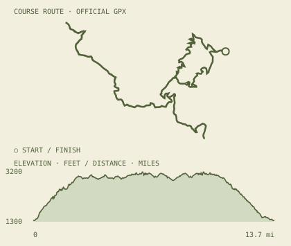
Trailquake Half Marathon
Redwoods, fire roads, and singletrack lead to the high point of Sanborn Park.
Typically heldMay*
Profile drawn from the organizer’s published route. Elevations and route versions may vary.
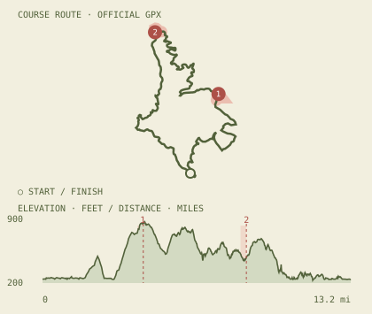
Bad Bass Half Marathon
A Lake Chabot loop with rolling hills and a power-hike climb up Live Oak.
Typically heldJuly*
Cutoff checkpoints
- Aid station · 4.3 mi
- Aid station · 8.7 mi
Profile drawn from the organizer’s published route. Elevations and route versions may vary.
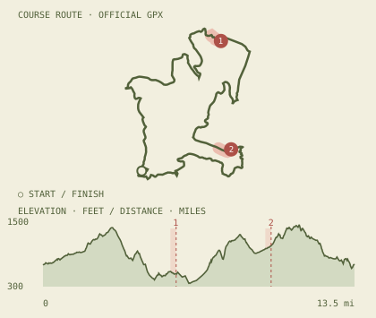
Bear Creek Half Marathon
A rolling Briones loop finishes with a shaded 1.1-mile singletrack descent.
Typically heldAugust*
Cutoff checkpoints
- Aid station 2 · 5.79 mi
- Aid station 3 · 9.92 mi
Profile drawn from the organizer’s published route. Elevations and route versions may vary.
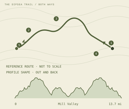
Double Dipsea
Stinson to Mill Valley and back on the Dipsea Trail, via Cardiac Hill, Muir Woods, and Old Mill Park.
Typically heldAugust*
- TURNAROUND
- CARDIAC
- MUIR WOODS
- OLD MILL / TURN
- START / FINISH
Published cutoff checkpoints: Old Mill Park (6.8 mi), Muir Woods Aid (8.6 mi), Cardiac Aid (10.6 mi).
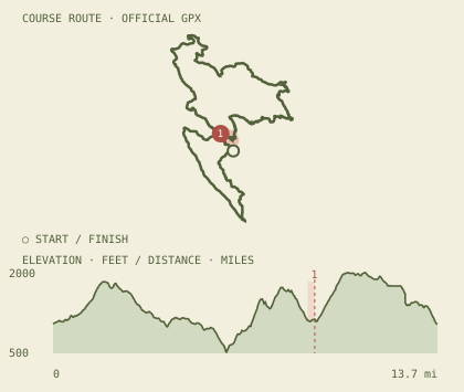
Rocky Ridge Half Marathon
A figure-eight through Las Trampas climbs out of the valley, crosses east, and reaches Rocky Ridge Trail.
Typically heldSeptember*
Cutoff checkpoints
- Aid station 3 · 9.36 mi
Profile drawn from the organizer’s published route. Elevations and route versions may vary.
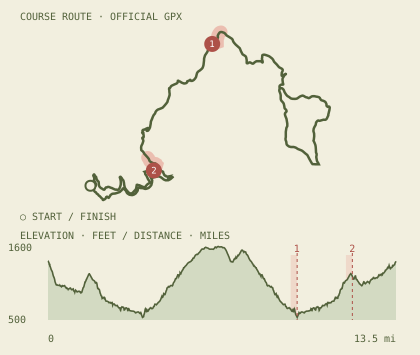
The Auburn Half Marathon
Western States Trail to No Hands Bridge and toward Cool, then back to Overlook Park.
Typically heldSeptember*
Cutoff checkpoints
- Aid station 4 · 9.7 mi
- Aid station 5 · 11.85 mi
Profile drawn from the organizer’s published route. Elevations and route versions may vary.
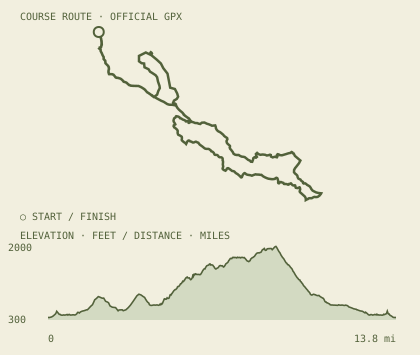
Diablo Summit Stomp
Dirt trails climb from Castle Rock into Mount Diablo State Park; the longer 30K reaches the summit.
Typically heldOctober*
Profile drawn from the organizer’s published route. Elevations and route versions may vary.
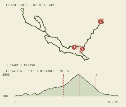
Diablo Summit Stomp
The longer climb runs from Castle Rock to the Mount Diablo summit, with a high-country return.
Typically heldOctober*
Cutoff checkpoints
- Helipad · outbound · 9 mi
- Summit · 12 mi
- Helipad · return · 15 mi
Profile drawn from the organizer’s published route. Elevations and route versions may vary.
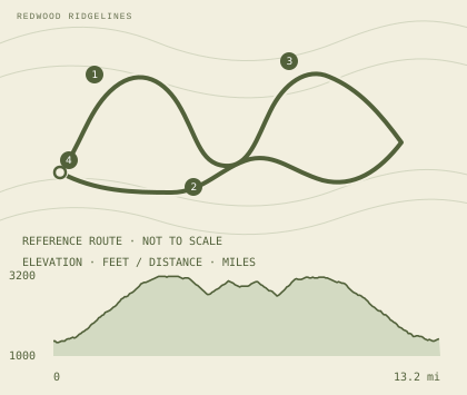
Summit Rock Half Marathon
Fire roads and singletrack climb through Sanborn’s redwoods to high ground and open views.
Typically heldDecember*
- SANBORN
- SINGLETRACK
- SUMMIT ROCK
- START / FINISH
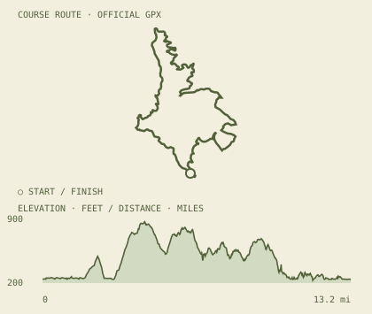
Brazen “Almost” New Year’s Eve Half
A rolling Lake Chabot loop, with the half course mostly on dirt trail.
Typically heldDecember*
Profile drawn from the organizer’s published route. Elevations and route versions may vary.
Route outlines and elevation profiles use the organizer’s published GPX data where available; Summit Rock and Double Dipsea use reference routes and original brand-styled redraws of the published profile shapes. Double Dipsea’s source is illustrative: its intermediate distances and elevations are not measured. Numbered pins identify published cutoff checkpoints. Salmon overlays mark the final quarter-mile approaching those checkpoints on GPS-derived routes. They do not represent observed abandonment rates. No reliable location-specific withdrawal counts were found. They are not to scale, not GPS traces, and not for navigation. Course details can change; check Brazen’s official maps before a race.